

No ThoroughFair - An Academic Decision
This is a spin off from the 3-part ThoroughFair series, looking at the one white elephant which remains - Rushy Hill and the eroding coastline!

Impact / Questions / Solutions / Problem
So far we have been looking at our thoroughfares through the eyes of traffic related issues. For all the analysis and questioning, one white elephant remains - the permanent problem. I won't lie - this one has been a headache.
The coastline is eroding - this is fact.
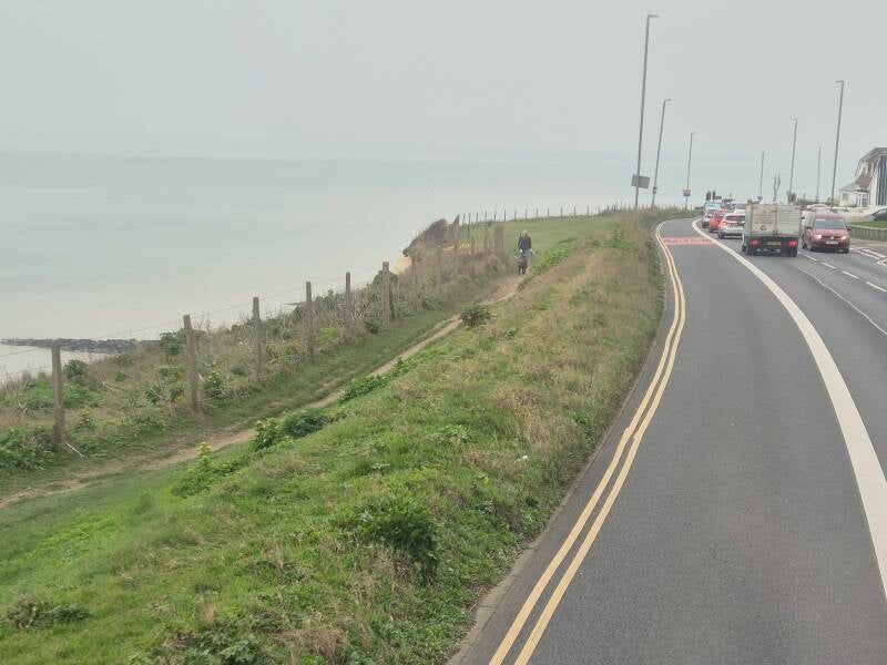
Given estimates of between 10 and 30 years, the coastline at Rottingdean and soil under Rushy Hill between Peacehaven and Newhaven means that time and tide may catch us up - climate change make it more so.
Recent coastal erosion has led access to Hope Gap, Burling Gap and Holy Well all being cut off because of rock fall or cracks in the cliff.
No geologist (I got D in GCSE), it doesn't take much to work out that soft soil, clay, chalk and water - having rained pretty much continuously since Christmas, don't mix.
There is already evidence of subsidence at Rushy Hill following resurfacing (and very noticeable on the bus!) and The Fairway is cracking. There is little enforcement of the 7.5 ton weight limit along here (which doesn't include buses).
At Rottingdean, either side of it in fact, the road is notably close to the cliff - Under which is the Undercliff walk, preventing much more serious erosion.
Slip diff
What happens in these two scenarios:
Rushy Hill
Peacehaven and Newhaven are split due to a sudden deterioration in road conditions forcing closure. There is a certain devolution based irony I won't explore here...
The highway between Peacehaven and The Fairway is single and only really able to accommodate 4x4's.
There is one road between Peacehaven and Telscombe that should ordinarily be closed and unsuitable for anything smaller than a jeep.
Buses cannot use either.
- 12/12A/12X would run via A259 between Newhaven and Rottingdean.
- Route 14C would be curtailed at Merdian Centre.
- Route 123 & 494 would need to divert back to Rottingdean and do the same at great time increase.
- Route 76A would need to be operated from another depot (as the AM bus comes from Newhaven depot).
- Shuttle bus may be provided between Rottingdean/Saltdean and Gladys Avenue (turning around using Arundel Road) and between Denton Corner and Kwik-Fit Garage (outside of working hours) or maybe the Golf Club!
Traffic would increase on Falmer Road, though Woodingdean, A27 and A26. Most Newhaven traffic would likely go along Lewes Road (former 701 route).
Rottingdean
At its narrowest point the bus lane would close first, leading to not minor hold ups for buses, then a single lane with lights or one way (who gets priority?) and then full closure.
There is a road around the closure unsuitable but not impossible for small single deck buses and less so double decks. The congestion and spacing as seen at Arundel Road would make it almost prohibitive for buses anyway.
Logistics for this would be almost impossible.
Routes 12-14C, 76/76A, N12/N14 would be diverted between Rottingdean and Newhaven via A27 & A26. 14/14C double backing to Peacehaven.
Both 27 & 47 initially only operating shuttles through Saltdean.
A shuttle service would operate between Newhaven and Saltdean.
Over time route 14, 27 and 47 may be amended to operate towards around the smaller roads or run East. Maybe to a combined timetable.
How people's walking behavior changes will be something to watch - will they walk a little further to get to Rottingdean or take a bus and walk between Saltdean and Rottingdean?
A table top exercise was proposed.
Lewes, Newhaven and Seaford would benefit from a closure with a need for new schools (catchments will change), hospitals (Lewes may become more needed) and other amenities, including night life. A lot of work being done for Brighton may be lost.
It goes without saying- A closure at both ends pretty much marooned.
Little fun?
A sidestep for the moment is this little nugget. The B797, a tiny road between Leadhills in South Lanarkshire and Wanlockhead in Dumfries and Galloway was shut for resurfacing. The diversion takes about 45 minutes by road. As as luck would have it, a nannow guage railway links the two: https://youtu.be/3WHmETKW72E?si=Yy7qzTKbF43ACGAr
An interesting point is what would happen if this was a significant closure?
New roads
In both our cases a relief road would be desirable. Some would say essential.
How big do we go?
The cost will be dependent on distance, demolition and structure. The shorter route may not be the cheapest. Cutting across may mean crossing SDNPA territory.
It is said that long term a new road would be needed. It also depends on how soon we do this.
Dare I say it, there is a lot of land to the north of Rottingdean, Saltdean and Peacehaven which could - simply be a new A259. It easy to imagine.
It is the by-pass concept magnified.
Do you build it in stages?
Where does it join? C7 or A26?
By-pass Rottingdean?
Single or duel in each direction?!
Bus lane both ways?
Closing both ends of the A259 and a whole new network is created. Again - do it now or wait for the road to be closed?
Getting the new ideas (buses, Cable Car, Boat, tram etc.) in place now, with the economic opportunities for Newhaven & Lewes - may only require a two lane A259 again (bus lane or otherwise) - increasing other modes as required to account for demand towards Brighton.
The interim
Who blinks first?
It's a known unknown - there are other quite profound examples of where key roads have collapsed. One being here at Swanscombe: https://www.bbc.co.uk/news/articles/cnvg37zm0j3o
In three years, a lot can change. The diversion there is 3 miles on regular roads. For Rushy Hill it's 19!
Rottingdean is a whole new kettle of fish.
So:
New connections?
New A259?
New lifestyle?
Last time I asked about what we do, now I double down - when do we do it?
Create Your Own Website With Webador